This weekend I was up in West Hartford’s Bishops Corner and chatting with a fellow bus rider who had walked to one of the nearby synagogues from the nearest stop, and let me tell you, their face looked like they had seen things. They kept saying “it is not safe” in a way that I wish engineers could have heard directly. It wasn’t pleading or angry or entitled. It was simply factual: this is not safe.
They did not need to say out loud that they were wondering if it was worth the risk to return for the following day for shofar. Because of a public transportation system that has lots of potential for improvement combined with streets that are hostile to pedestrians, someone is likely to miss participating in spiritual activities that they told me were meaningful to them. The Community spends a lot of time, understandably, preparing for scenarios like active shooters, but I would welcome their expansion of the definition of safety. Can members/visitors safely reach the building’s entrance from each nearby bus route’s stops, or are there inexcusable obstacles?
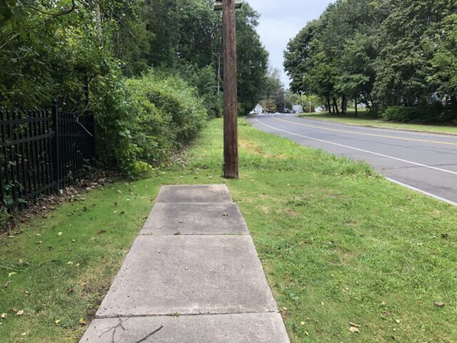
What my fellow bus rider was referring to is how the sidewalk dramatically ends, and one finds themselves on a road where people drive at speeds that will definitely be deadly to pedestrians. There is sometimes grass, sometimes not. It’s not especially dignified: who wants to walk on the side of the road to religious services in their nice clothes during the daytime? Who would even attempt this at night?
There are perhaps workarounds, but they are not reasonable asks: attempting a back entrance via windy suburban roads — not a grid system — that also often do not have complete sidewalks. The difference is that here, so long as it’s daylight, someone can walk on the pavement and have a shot of not getting killed. For my fellow bus rider, that alternate way would be a 40 minute hilly walk. The more direct, but dangerous, way is a 15 minute hilly walk.
This does not exemplify a town doing its best. It can’t.
This was not the case of one “oops”.
Take a look at King Philip Drive — the stroad that another stroad, Trout Brook Drive, turns into. This is a road people would use to access multiple synagogues on Route 44 (Albany Avenue) and Mohegan Drive, and depending on where one is coming from or going, it might make the most sense to be on the west sidewalk, especially if hoping to cross somewhere less terrible than the Trout Brook/Route 44 intersection.
But, surprise!
You don’t get a sidewalk!

And you don’t get a sidewalk!

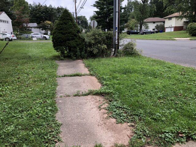
This one is on Mohegan and wow does it feel especially aggressive that not only does the sidewalk stop, but there are shrubs to force people to be either super trespassers or walk in the street. By the way, this is right next to a foot/bike path entrance to a middle school, so it has an extra layer of ickiness to it. But at least the speed limit is either 25 or 30, instead of the 30 or 35 on King Philip Drive, which motorists seem to think is a minimum, not maximum.
Even ickier, these are not just three oopses. This is intentional design through this part of town. Wide roads and sidewalk that sometimes you see it, sometimes you don’t. Considering how many people’s monster SUVs were parked in their driveways because they are too large to fit in their garages (that’s a whole other discussion), you can’t feel too calm about it.
And it’s puzzling because this is an area where many Jews live who are going to be walking to synagogue at least one day each week, and on certain major holidays. I mention this because people can try to say that recreational walkers should pick safer routes, but we are not talking about exercise fiends who also absolutely deserve safe routes too. Here, we’re talking about those who have a constant and predictable reason to be walking on certain routes — the homes are over here and the synagogues are over there — and how this is nothing new that engineers suddenly had to consider. This has steadily been the case for multiple generations. While walking in roadways works in some areas like parts of Queens, the neighborhood in West Hartford is not made up of only people who are out walking on these days, making it so it’s unusual to see someone driving through. Even if it were, there are the other six days of the week when people should be free to safely walk where they need and want to go.
Once upon a time, there were shuttle bus services from a parking lot in Bishops Corner to at least one of the area synagogues during the High Holidays; this appears to have been discontinued. It would not solve the bigger issues — that is up to the Town of West Hartford along with CTDOT and CTtransit to do — but would facilitate access to synagogues on at least three days during the year.
I don’t know what my bus buddy decided, if they returned for more Rosh Hashanah services or opted out because getting there was too harrowing. But either way, this is something both the decision makers for the Town of West Hartford ought to reflect on, along with those with pull at the area synagogues: how can and should the community and The Community work toward fixing roadways and public transportation, to better serve those already involved and engage those who would be but don’t want to die trying?
Tomorrow, Tuesday September 19, 2023, there will be a public meeting about West Hartford’s Vision Zero Action Plan. This will take place from 5:30-7:30 PM, in the Town Hall Auditorium at 50 South Main Street. There will be an opportunity to provide comments. If you miss it, there will be a second one later this year. And if you just won’t waste your time in meetings, you can provide input via survey and interactive map. Let them know that their excuses for absent sidewalks ends here.
//
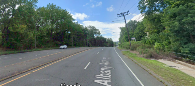
The top photo is a Google Map screenshot showing where the sidewalk ends on Route 44/Albany Avenue just beyond the Staples plaza. If someone wanted to reach the synagogue 0.3 mi west, how would they do this?
Climate Possibilities is a series about climate mitigation, along with resilience, resistance, and restoration. It’s about human habitat preservation. It’s about loving nature and planet Earth, and demanding the kind of change that gives future generations the opportunity for vibrant lives. Doomers will be eaten alive, figuratively. All photographs are taken in Hartford, Connecticut unless stated otherwise.


Jim Head
Fun fact: the survey includes questions like “do you reside in West Hartford or travel here frequently?” so it’s not exclusive to WeHa residents – anyone using the paths/roads are welcome to take the survey, thumb up comments and/or create their own comments and ideas on the interactive map.
Also I’d recommend attending the VZ Town Hall tonight. This month was the first month the Pedestrian and Bike Commission had to cancel a meeting because they were one commissioner short of a quorum. I understand everyone has something going on and it’s frustrating the “safety” meetings are now split between a commission and a task force. My hope is the Task Force comes up with a plan that includes a better feedback process between residents, visitors, and the existing commissions (plural because the environmental conservation and sustainability commission is also affected). The fact so many meetings in this Town are in-person only, without a zoom option to attend is entirely behind the times.
Kerri Ana Provost
Thanks, Jim!
Definitely should have mentioned that the survey and map are both open to ANYONE who uses the roads. And that matters, because lots of people who work in WH’s retail and restaurants live in Hartford, and I know this from riding the bus and seeing who gets off at which stops in their work clothes. Whether or not someone pays property taxes in a particular town does not and should not give them more of a voice when they are not the only ones using the facilities.