After a driver struck a pedestrian on North Main Street in West Hartford on November 29, 2023, the injured pedestrian was ticketed. Officially, the infraction was for “reckless use of the highway by a pedestrian.” Police apparently plan to reveal nothing else about this matter, though eventually the details should wind up in the CT Crash Data Repository.
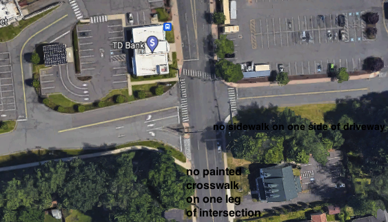
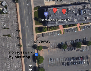
This collision happened at 333 North Main Street, on the block between Sims Road and Route 44 (Albany Avenue). The people most likely to cross the street here are going from the bus stop to the other plaza where they work or need to shop. None of the bus stops closely align with crosswalks. Even if they did, the marked intersections do not feel much safer as a pedestrian.
It is obnoxious to ticket someone for “reckless use of the highway” when the Town of West Hartford has provided no non-reckless way for this area to be used. Judging from their weak street revision plan for this area, the Town of West Hartford also has made no commitment to creating safer streets. Going forward, anyone with the power to issue fines or decide how pedestrians “ought” to be using public space should be required to use it themselves, like a normal person: while carrying parcels, in civilian clothing, not wearing construction worker vests, when they have to catch the bus. They should have to experience the road as an individual, and not in a group. Then, and only then, should they have any say over how people outside of cars can move about in the space. You do not understand street safety if you exclusively experience roads from inside of a vehicle or through a curated pedestrian experience.
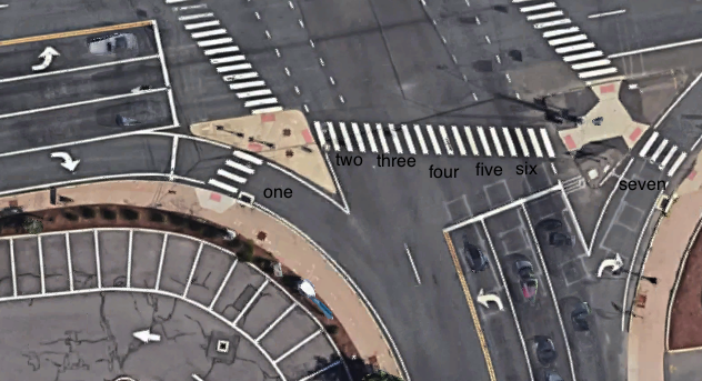
There have been multiple crashes on this block of North Main Street this year. In April, a driver using a slip lane to go from Route 44-East onto North Main Street (southbound) hit a cyclist who had been traveling straight on North Main Street, had the green light, had the complete right-of-way. Obeying the law did not protect the cyclist. You can see this delightful intersection on the map below:
Back to the experience of the pedestrian: the speed limit on this block is 35 MPH. There are either four- or five-lanes a person has to cross, if attempting to do so mid-block where rational behavior is forbidden.
To use the road in a way that might not result in a ticket, a person is asked to walk down to the corner by Route 44 and then use a marked crosswalk taking them across SEVEN lanes of traffic. This includes two slip lanes. Slip lanes mean that motorists can, and do, turn right on red constantly, often without stopping or even pausing. This is a threat to those walking.
Additionally, and maybe police are unaware of this fact: there is no exclusive pedestrian phase. At this intersection pedestrians are given a walk signal, but traffic in the direction they are traveling still has the green light. If all motorists obey the signals and signs, this should not present an issue . . . but when do motorists follow all laws? What is stopping someone from making a left turn directly into the pedestrian who is using a marked crosswalk with the Walk light on?
When I have used this intersection, that is at the forefront of my mind. But at least when lazy reporters give two paragraphs to my demise, they can say that “police believed the pedestrian was using the crosswalk.” I’m sure my ghost will care.
When you see how easily drivers can travel between plazas, and then see how few legal options pedestrians have, you have to feel it as an equity issue.
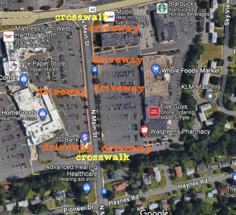
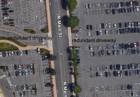
On this one block between Sims and Route 44, there are three commercial driveways on the east side and one on the west side that a pedestrian would potentially have to cross over to reach a marked crosswalk. None of these curb cuts have traffic signals, though there are numerous car crashes there and anyone with sense would say that these redundant driveways should be eliminated entirely. Drivers make quick turns into and out of the plazas, and bad design leads to predictable results: crashes.
Down the road, at the other legal crossing, the pedestrian would have to contend with four lanes. This seems better, but motorists are permitted to make right turns on red, which means that they are able to exit plaza driveways and into pedestrians using the marked crosswalk.
Those arriving on an outbound 62, 72, or 153 bus may get off at the stop before the intersection with Sims Road (the name given to the driveway that curves around the Target plaza before exiting by Flagg and Route 44). There is no marked crosswalk taking them to the sidewalk across the street. Instead, they are told to cross a plaza driveway; the Town of West Hartford permits motorists to turn right on red from North Main Street into the Whole Foods plaza, leaving pedestrians continuously vulnerable to collisions.
Additionally, those arriving at this stop and wanting to simply reach the plaza on the same side of the road still have to cross the plaza driveway because there is sidewalk only on one side of the driveway.
Or, instead of all that, a pedestrian traveling to/from a bus stop could cross illegally, in a direct and efficient way, where they are most likely only dealing with vehicles traveling north or south.
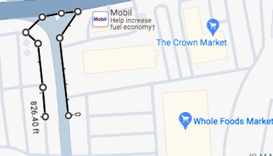
Here is what this kind of illegal crossing from bus stop to sidewalk looks like when measured:
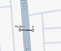 To cross the road directly from the bus stop, someone would be walking for about 57 feet.
To get where they want to go legally, their measured route looks like this:
I’ll just say it: this is dumb.
That’s 57 feet across four lanes versus 826 feet across seven lanes.
The logical route is the one that is short and direct.
After all, the cyclist who was hit in April was riding legally and had the right-of-way.
Both the cyclist and the ticketed injured pedestrian were using a shoddily designed road.
We could be asking why police did not issue the Town of West Hartford an infraction for allowing reckless infrastructure to exist.
The sad thing is that ticketing an injured pedestrian or cyclist is not that uncommon. This just doesn’t usually make the news because the crashes that the media typically cover are fatalities, and much to the chagrin of the law and order crowd, you can’t ticket a dead person. Probably.
What you can do about this is show up at West Hartford’s Vision Zero meeting on December 6, 2023 and ask questions.
Why? Because at least three pedestrians were killed on Connecticut’s roadways in November, and two of those three preventable deaths are clearly connected to poor road design — both involving Route 1. If you could prevent someone’s death, why wouldn’t you?
One of those fatal collisions happened on Route 1 in Orange on November 14, 2023.
On that Tuesday evening, a driver struck and killed a pedestrian — Khurshida Mohamadi, of West Haven — in front of the drive-thru McDonald’s on Route 1, a stroad in Orange.
Despite the bus stops in this area and multiple businesses where people taking the bus, cycling, or walking would need to go, there are no sidewalks.
From the Google Map updated last year, you can see people waiting for the bus in the street. There are numerous curb cuts (driveways) here, which poses a danger for pedestrians. There is no actual median on Route 1.
At the nearest intersection, the crosswalk is not painted on all legs. There is also no pedestrian infrastructure here, as the two beg buttons on the corner are not for an exclusive pedestrian phase, but to trigger a green light for drivers. Because drivers are permitted to turn right on red, pedestrians at the nearest intersection never realistically have the right of way, even if that is their legal right. The speed limit is 40 MPH. This formula for disaster should sound familiar by now.
In January 2023, a driver hit and injured a pedestrian in this same location; they were turning left out of a driveway, and based on the lack of information about vehicle damage, it appears this was a hit-and-run. In December 2015, a driver making a left turn out of the McDonald’s driveway hit and injured a pedestrian. At the nearby intersection with only one painted crosswalk, a driver injured a pedestrian in September 2023. In 2016 there was another pedestrian fatality on Route 1, 0.7 miles away where the road design is the same. We know that this street is a hellscape for pedestrians because if you ask Google Maps for walking directions between that site and the McDonald’s — a trip that takes one minute by car — it sends you on a 2.6 mile circuitous route that takes 54 minutes, due to the utter lack of usable pedestrian infrastructure.
This is the model of car-centric, negligent design. You can ask the decision-makers in Orange what they are planning to do to reduce the chances of anyone else dying here. Ask them and keep asking.
Another fatal collision strongly connected to poor road design happened on November 21, 2023. This was on Route 1 in Stamford close to the Greenwich border.
Marie Jean-Charles was a cashier at ShopRite for 25 years.
A speeding driver of a red sedan struck and killed 74-year old Marie, who was crossing Route 1 at 6:13 AM. She was pronounced dead at the scene. Marie had just gotten off of a bus and was on her way to work.
By the intersection of Route 1 and Alvord Lane, an elderly pedestrian had been tasked with crossing six lanes of traffic. There is no physical median. Stamford only bothered to paint crosswalk on three legs of the intersection on this stroad where there are numerous stores and bus stops nearby. One of those crossings appears faded. The fourth leg, an unmarked crosswalk, is a place where people can legally cross. Drivers turning out of the plaza or Alvord Lane are permitted to turn right on red, making the signalized crosswalk less of a safety zone for pedestrians.
There are no sidewalks along Commerce Road. There appears to be a narrow sidewalk on Laddins Rock Road in Greenwich, but there does not seem to be a reliable back entrance to the plaza from this side street, and Marie would still have been asked to cross a street without a crosswalk. There is sidewalk along Route 1 and the sidewalk that continues from there into the plaza is not located at the intersection, though it is across the street from where the westbound bus stop is located. It is as if these roads — inside and outside of the plaza — were designed by those who would never walk on them.
Speed limit? There is apparently no consensus on that. Records in the UConn Crash Data Repository showing 32 previous crashes since 2015 at Alvord and Route 1 state the speed limit as being: 25, 30, 35, and 40. Based on the severity of the victim’s injuries and damage to the vehicle, it is unlikely that the motorist was traveling below 30. Why would he? The road was designed to prioritize Level of Service (speed).
Since 2015, four pedestrians and one cyclist have been killed by drivers on Stamford’s section of Route 1. So far, reporters have said nothing about if Stamford or the State of Connecticut would be held liable due to their negligent road design. You can ask decision-makers from Stamford how they will be fixing Route 1 so that nobody else is killed or seriously harmed when all they are trying to do is go to work. Ask them and keep asking.
The fatal pedestrian collision on November 1, 2023 in New Britain also involved less-than-stellar design, though not as glaringly terrible as Route 1. Around 9:15 PM, a driver struck and killed Brenda Catucci, 62 of New Britain, on Route 71 in New Britain. Brenda was crossing the street to return home from a convenience store. This area has a large apartment building, a fire station, Dunkin Donuts, and other places where a person would want to walk, plus bus stops. The speed limit is 25 MPH. There’s a marked crosswalk with no pedestrian signal. There are lights present, but we’ll have to wait for the report to see if they were operating at the time. New Britain, unlike most other municipalities, has been relatively responsive about fixing shite roads. Still, you can ask New Britain’s decision-makers how they will improve Route 71 so that folks can safely cross the road from their home to the store. Ask them, and keep asking.
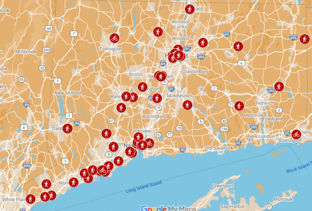
So far in 2023, at least 52 pedestrians and cyclists have been killed as the result of traffic violence in Connecticut.

Jim Head
This is a horrible place to cross N Main or Rt 44. Because I come from the West, I’ll go to Target or Noodles, but rarely consider crossing to Whole Foods or Walgreens. Big Y?… across both N Main AND 44 with no dedicated pedestrian phase to cross diagonally, I have never been to. Traffic will always be a problem here until they figure out how to many it safe for people outside of cars.
Kerri Ana Provost
What it takes, besides political will, is for people in cars to realize that they too are considered collateral damage . . . and then they need to tell decision-makers that this is an unacceptable way to live.
Kerri Ana Provost
Looked like there was a packed house for the West Hartford Vision Zero meeting — good.
Jim Head
*how to MAKE it safe for people outside of cars
Lessons from Mapping Death – Real Hartford
[…] or otherwise make nonsensical detours in order to cross the road legally. This is an equity issue. Drivers are not consistently told to make five minute loops to achieve what could be done in thirty …. Our current design and system largely does not value pedestrians’ time or […]